Satellites Over the Soil: How Precision GPS Is Helping Australian Farmers Survive a Drying Climate
For generations, Australian farmers have operated according to instinct, experience, and a close reading of the sky. Rainfall was unpredictable, but it was at least familiar in its unpredictability. Today, however, the patterns that sustained entire farming communities are shifting in ways that defy even the most seasoned agricultural intuition. Extended drought cycles, erratic rainfall distribution, and rising evapotranspiration rates are placing extraordinary pressure on the sector — and on the underground and surface water systems it depends upon.
In response, a growing cohort of Australian growers is turning not to the sky, but to space. GPS technology, once the exclusive domain of defence and surveying, has become an essential instrument in the modern farmer's toolkit. And the results, emerging from properties across New South Wales, Victoria, South Australia, and Queensland, are beginning to demonstrate that satellite-guided agriculture is not merely a technological novelty — it is a practical response to an existential challenge.
From Paddock to Pixel: The Rise of Soil Moisture Mapping
At its core, precision agriculture rests on a deceptively simple principle: different parts of a paddock have different needs. Soil composition, elevation, drainage characteristics, and sun exposure can vary enormously across even a modest-sized property. Traditional irrigation practices, which apply water uniformly across a field, inevitably over-water some zones while under-serving others. The result is both economic waste and environmental harm.
Geospatial technology addresses this inefficiency directly. By combining high-resolution GPS positioning with ground-based soil moisture sensors and satellite imagery, farmers can now generate detailed spatial maps of their properties — maps that reveal, with centimetre-level precision, exactly where water is needed and in what quantity.
Researchers at Monash University's geospatial science programme have been instrumental in refining the algorithms that translate raw sensor data into actionable irrigation prescriptions. Working in collaboration with agricultural partners in the Murray-Darling Basin — one of Australia's most water-stressed regions — the team has developed layered mapping frameworks that integrate satellite-derived vegetation indices, real-time GPS telemetry from irrigation pivots, and historical soil data. The outcome is a dynamic picture of farm-level water demand that updates continuously as conditions change.
Case Study: Variable-Rate Irrigation in the Riverina
Among the most compelling examples of this technology in practice is its adoption across irrigated cropping properties in the Riverina district of New South Wales. In this region, where cotton, rice, and winter cereals are grown at scale, water allocation is both economically critical and politically fraught. Licence holders face strict volumetric limits, and the cost of water on temporary markets has risen sharply over the past decade.
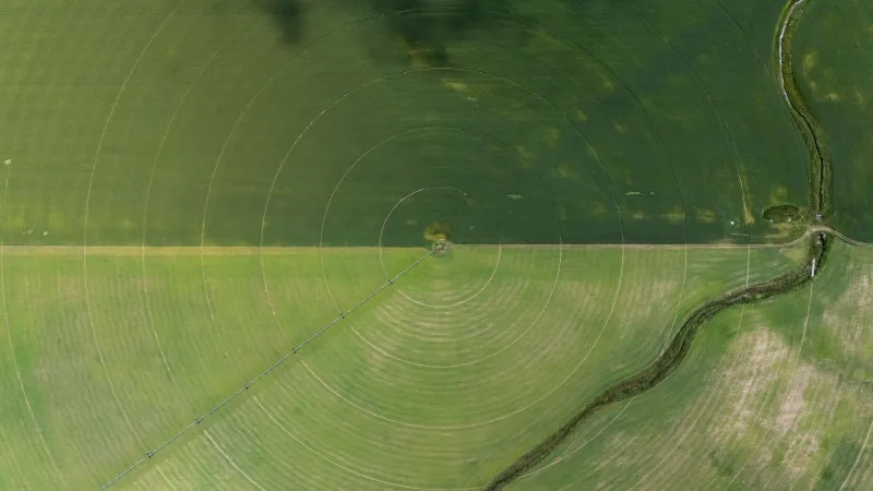
One broadacre cotton grower operating near Griffith has implemented a GPS-guided variable-rate irrigation (VRI) system across approximately 1,200 hectares. The system draws on electromagnetic induction surveys to classify soil types across the property, overlays this data with GPS-referenced yield maps from previous seasons, and uses the resulting model to instruct centre-pivot irrigators to apply different water volumes to different zones as they rotate across the field.
Over two consecutive growing seasons, the grower reported a reduction in total water applied of approximately 18 per cent, with no statistically significant decline in yield. In dollar terms, at current water market prices, that efficiency gain represents a considerable saving — while also reducing the volume of water extracted from an already-stressed river system.
Satellite Imagery and the Early Warning System Farmers Never Had
Beyond irrigation management, GPS-enabled remote sensing is providing Australian farmers with something they have long lacked: an early warning system for crop stress. Multispectral satellite imagery, georeferenced to GPS coordinates with high accuracy, allows agronomists and growers to detect subtle changes in crop canopy that precede visible signs of drought stress by days or even weeks.
The Normalised Difference Vegetation Index (NDVI) and its more sophisticated derivatives are now routinely used across Australian grain and horticulture regions to identify areas of a paddock where crops are beginning to struggle. When these signals are integrated with GPS-tagged irrigation records and local weather data, farmers can intervene earlier — and more precisely — than was previously possible.
Monash researchers have been exploring the integration of these satellite signals with machine learning models trained on Australian-specific crop and climate data. Unlike overseas models, which may not account for the distinctive soil types and climate variability found across southern and eastern Australia, locally calibrated systems can provide far more reliable stress predictions for Australian conditions.
Water Policy Meets Geospatial Science
The implications of this technology extend beyond individual farm gates. As GPS-derived water-use data becomes more granular and reliable, it is increasingly informing policy conversations around water allocation, trading, and environmental flows.
State and federal water authorities are beginning to explore how spatially referenced farm-level data can be incorporated into basin-scale water accounting frameworks. If adopted at sufficient scale, precision irrigation data could provide regulators with a far more accurate picture of actual on-farm consumption — replacing estimates derived from metered extractions at pump stations with real-time, GPS-verified usage records.
This prospect raises important questions about data governance, privacy, and the equitable distribution of the benefits that geospatial technology generates. Monash researchers engaged in this space have been careful to emphasise that the value of farm-level location data should accrue primarily to the farmers who generate it — and that any policy frameworks built around this data must be developed in genuine partnership with agricultural communities.
The Road Ahead
Precision agriculture powered by GPS and geospatial science is not a silver bullet for the water challenges facing Australian farming. Adoption rates remain uneven, particularly among smaller operations where capital investment in sensing and guidance technology can be prohibitive. Connectivity limitations in remote agricultural regions also constrain the real-time data transmission that many of these systems depend upon.
Nevertheless, the trajectory is clear. As satellite positioning technology becomes more affordable, as sensor networks expand, and as the analytical tools developed by researchers at institutions like Monash become more accessible, the gap between what is technically possible and what is practically achievable on Australian farms will continue to narrow.
In a country where water is arguably the most contested natural resource, and where the agricultural sector faces mounting pressure to demonstrate its environmental credentials, GPS-guided precision farming represents one of the most credible pathways toward a more sustainable and resilient food system. The satellites are already overhead. The question now is how quickly Australian agriculture can learn to use them.